Watershed Modeling ( Site Suitability Analysis for Water Harvesting Structures )
Forest department is one of the Seven departments
involved in implementation of NABARD assisted RIDF projects. under
this project large number of Water Harvesting Structures like
Check Dams, Percolation Tanks, Contour Trenches, Rockfill Dams
etc., are being taken up. Geomatics could be used in selecting
suitable sites for water harvesting structures based on criteria
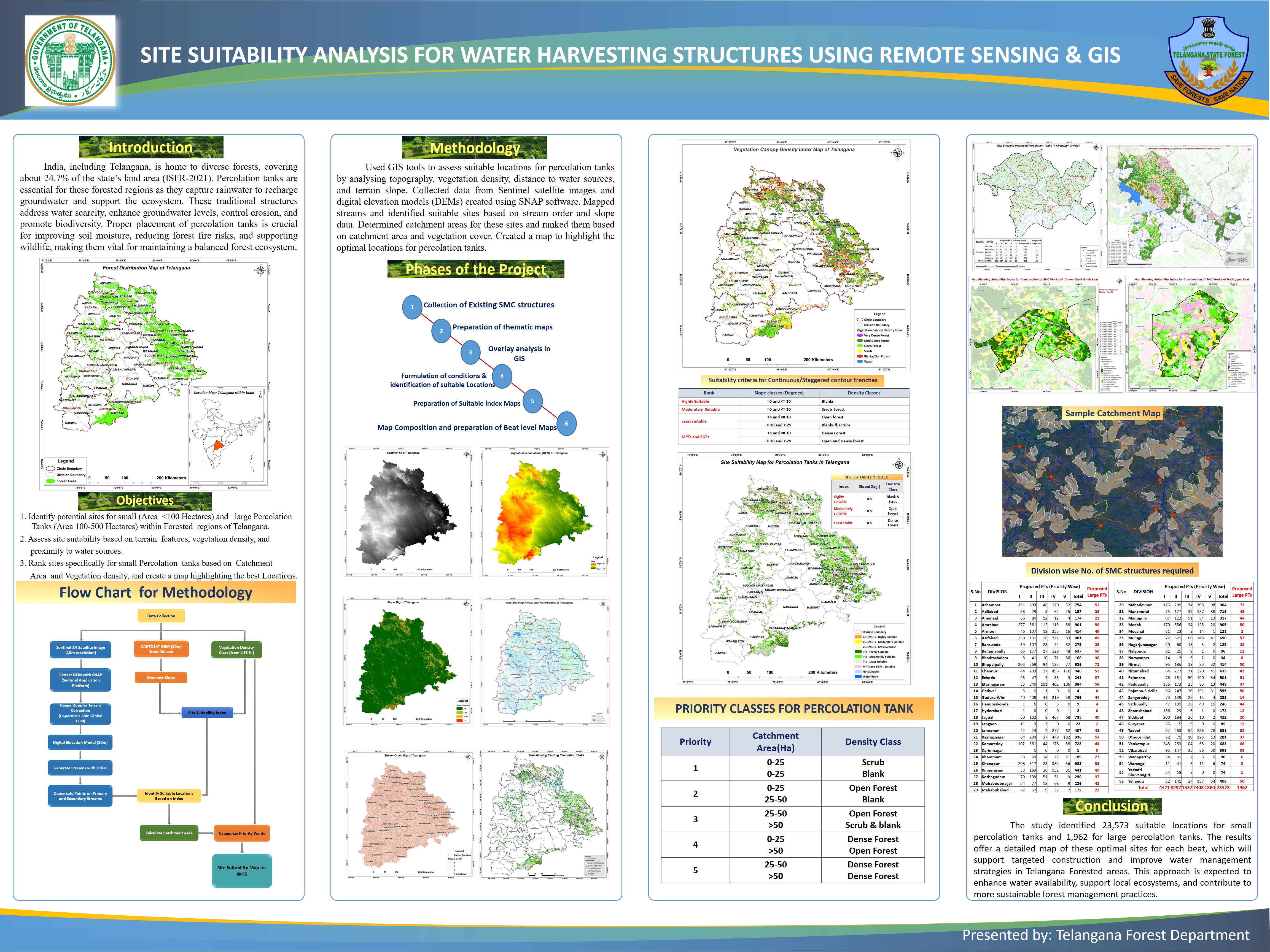
and budget availability. Telangana is covering with 2,800
Beats (smallest administrative unit) in 43 territorial Divisions.
The main objective of this project is to provide Beat wise maps for entire state with the site suitability index for construction of various water harvesting structures (WHS) along with related information and indicating locations of Check dams and Percolation tanks based on suitability index map along with latitudes and longitudes.The input themes like the stream network, the DEM and slope generation, the vegetation canopy density, watershed area etc has been used for the analysis. The analysis is carried out only for the reserved forest areas since the Forest Department is taking up the watershed treatment in forest areas only. In the analysis all input themes were overlaid in the complex GIS environment to derive the site suitability index for Water Harvesting Structures by framing various rules as per the guidelines given by IMSD and the central and state governments from time to time. The suitable sites for construction of check dams, percolation tanks etc are selected and its spatial information is calculated. The final maps are composed beat wise for all the beats in the state with the detailed information and appropriate legend at 1:25000/50000 scale as per the requirement suitability index for various SMC structures, administrative, compartment, JFM boundaries, drainage network and contours, roads and villages, watershed boundary, or the other topo features if required, the serially numbered points showing the suitable locations for various structures for which the latitude and longitude were given on map and disseminated to the field for the feedback and implementation.
Micro Level Watershed Management Planning using Geomatics for specific areas:
The DGPS system has been employed to collect the fly levels in the area by walking in a zigzag fashion in such a way that the entire area is covered uniformly depending upon the terrain. The information has been utilized for generating contours at 1 mt interval and slope and stream network is derived. By inputting various criteria the site suitability analysis for WHS is carried out. The runoff is estimated using other parameters governing the watershed development.