Vegetation Mapping and Monitoring:
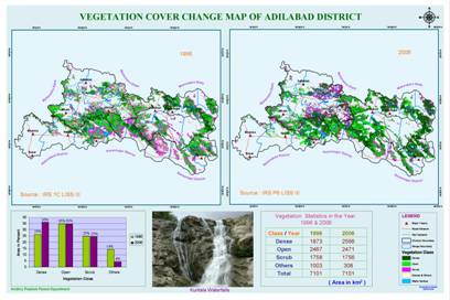
Remote Sensing data of 1988, 1996, 1998, 1999, 2000, 2002, 2003, 2003, 2004, 2005 and 2006 have been processed and classified into various canopy density classes and these have been used for monitoring the forest canopy density changes in Telangana. The year 2007 and 2008 data is under processing. The data has been sent to field officers for ground verification. The errors are rectified and maps with detailed statistics are generated up to the lowest administrative, management and extension levels. The maps are being used in the plans of the departmental staff. The status of forest reports are generated for all years. New standards in classification accuracy were established by extensive ground truthing and accuracy assessment by involving the ultimate end users i.e., Forest Beat Officers. The change detection analysis has been carried out.